Overview
Bassari's exploitation and exploration permits cover a large area of approximately 312km2 in a central location of the highly prospective Birimian belt of the Kedougou-Kenieba Inlier. The Moura and Sambarabougou permits are located in the Tambacounda region of south-eastern Senegal, 700km east of the capital city of Dakar, and approximately 70km north-east of the town of Kedougou. The north-east boundary of the Moura permit is along a portion of the Faleme River which forms Senegal's border with Mali.
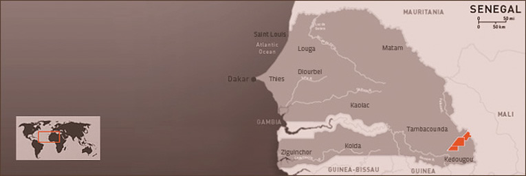
Bassari Resource's permits include Moura and Sambarabougou which are located in the Tambacounda region of South Eastern Senegal
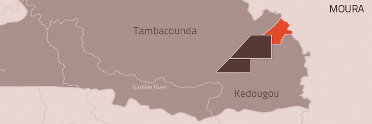
The Moura permit area of 184km2 covers a very prospective part of the Diale Formation of the Birimian Belt adjacent to the Senegal Mali Shear Zone (SMSZ) which hosts the large Loulo and Sadiola gold operations in nearby Mali.
Moura has been subject to exploration by the United Nations, the French Government (BRGM) and a number of private mining groups, including Bassari Resources Senegal. BRGM had identified 30 gold anomalies for follow up exploration. All of these anomalies have been located by Bassari Resources Senegal and a detailed geochemical sampling program completed. Infill sampling by Bassari Resources Senegal geologists has identified at least 7 extensive NE-SW trending anomalous zones, centred around Kawsara and Kawsara North (5 km strike length), Benajiggi (4 km long), Konkoutou (2 km long), Yoroya (1.5 km long and open to the north), Sambali and Bountou. A limited drilling program has confirmed the identified anomalous zones.
Moura is considered a a highly prospective permit for detailed further exploration and development.
At the Konkoutou prospect, trenching by UNDP (Soviet) geologists discovered 10 small isolated auriferous zones. Follow up sampling by the Bassari geologists confirmed the prospectivity of the area.
Bassari's geologists logged and sampled 49 pits. All of the pits exposed quartz veins and quartz stock works. The abundance of pits allowed five profiles to be selected and constructed across the Konkoutou Hill and valleys to the east and west. Significant gold mineralization was located in all five pit profiles. The mineralised zones suggested there could be a major east-dipping shear zone developed within the Konkoutou prospect. This zone was evaluated by RAB geochemical drilling and returned 20m @ 1.7 g/t Au. Konkoutou is a priority drilling target for Bassari.
Exploration drilling has returned high-grade intercepts from diamond drill hole DDM004 on Section L214750E. The results include 2m @ 20.9 g/t gold from 164 metres and 2m @ 10.9 g/t gold from 173 metres. The results confirm continuity of mineralization, which remains open at depth.
Previous significant drilling results returned from diamond drill hole DDM003 on Section L214950E where visible gold was identified in drill core include 9m @ 11.5 g/t Au from 161 m including 3m @ 33.9 g/t Au from 162m and 3m @ 3.9 g/t Au from 101m including 1m @ 10.2 g/t Au from 102m.
To date drilling has intersected gold mineralization over a strike length of some 450 metres.
A total of 3240 metres in 40 RC holes and 1082 metres in 5 DD holes were completed in the 2011/2012 drilling programs.
More recent drilling results from the November 2016 RC and DD drilling of 2,922 metres include:
Consulting geologists have reported that Konkoutou has the potential to develop into a major gold deposit.
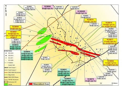
The Konkoutou North prospect (approximately 2km north of Konkoutou) comprises a low hill made up of massive and locally brecciated milky quartz veins. The best results from trenching work (quartz vein channels) by UNDP geologists were 75 g/t Au and 110 g/t Au over widths of 0.5 metres. These high-grade results have been reconfirmed by Bassari geologists.
The most recent drilling in November 2016 produced 6m @ 6.3g/t gold from 21m, 3m @ 5.1g/t gold from 53m and 4m @ 2.3 g/t gold from 29m.
Located 2.5km east of Benajiggi, the Konkoutou East prospect is defined by soil geochemistry over a 0.5km strike. Gold-in-soil values above the 25ppb contour peak above 600ppb. Yoroya is a RAB and RC drilling target.
Kawsara is located 3km north of Yoroya. Kawsara and Kawsara North prospects define a NE trending zone of strong soil geochemistry over a strike of some 5km. Gold-in-soil values peaks above 800ppb. Trenching by Bassari has concentrated on a zone over a strike length of 800m and values returned included 3m @ 3.4 g/t Au, 2m @ 5.5 g/t Au, 5m @ 5.7 g/t Au and 3m @ 3.4 g/t Au. Kawsara is an RC drilling target.
Covers a very prospective part of the Diale Formation of the Birimian Belt adjacent to the Senegal Mali Shear Zone (SMSZ) which hosts the large Loulo and Sadiola gold operations in nearby Mali.
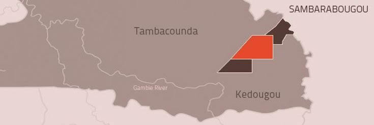
The Sambarabougou permit is located within the Palaeoproterozoic Birimian volcano-sedimentary sequences and the intrusives of the Diale Formation. Early-stage exploration near the southern margin of a small syntectonic granite, the Sambarabougou Granite, led to the discovery of the Makabingui gold deposit , which comprises a large number (>30) of generally shallow east dipping lodes and quartz veins hosted by a gabbroic intrusive and contact metasediments. This structural setting is deemed highly prospective by Bassari geologists.
In 2017 Bassari applied for an exploitation permit covering 128km2 to mine the gold contained in 4 high grade pits at Makabingui. The permit was granted for a period of 5 years, renewable with the exhaustion of the deposit. The exploitation permit also inlcudes the 8km of strike at Makabingui South.
Sambarabougou also contains the alluvial gold area of Douta.
Bassari is also exploring a major gold corridor immediately south of Makabingui. Previous shallow drilling and recent artisanal mining has confirmed widespread gold mineralization in this area.
Makabingui South is along strike from the Makabingui Gold Project which has returned outstanding feasibility results. Makabingui South is defined by highly anomalous soil and termite mound gold anomalies and significant gold intercepts returned from previous wide spaced RAB & RC drilling (~400 metre spaced lines). Structural interpretation indicates the presence of a major mineralised gold corridor. As well as alluvial gold artisanal's have previously mined quartz lode hosted gold mineralization in the weathered bedrock.
Previous artisanal activity within the Makabingui Gold Project area south of the existing resource has identified potential for multiple new areas of mineralization within a regional NE trending shear zone (Main Transcurrent Zone – MTZ) - (refer Figure 1).
Within the overall prospect area gold mineralization is expected to occur within dilational sites that formed in local perturbations along the recognised cross-cut faults during structural reactivation. Bassari has identified three priority infill drilling areas south of the existing gold resource MS1, MS2 and MS3 (refer Figure 2).
The MTZ is viewed as a long acting and wide zone of crustal deformation which acts as a primary regional and crustal scale control for the existing gold deposits and gold mines in Mali and Senegal. Previous soil and termite mound sampling results clearly indicate highly anomalous gold mineralization along the length of the MTZ regarded as one of the primary controls of gold mineralization (refer Figure 3).
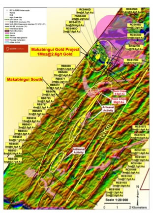
Figure 1. Makabingui & NE Trending Mineralised Zone
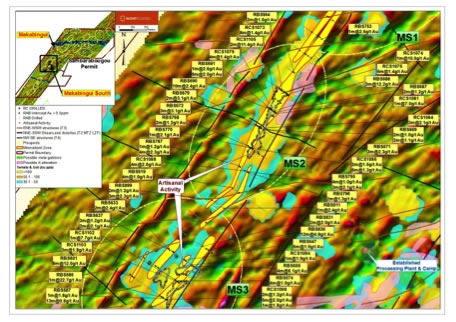
Figure 2. Makabingui South Propsect
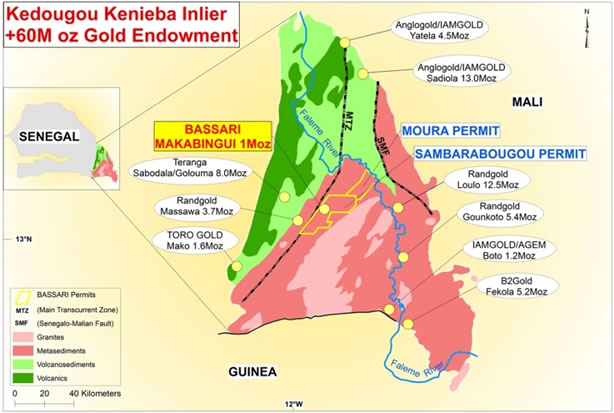
Figure 3. Kedougou-Kenieba Inlier
Located within the Palaeoproterozoic Birimian volcano-sedimentary sequences and the intrusives of the Diale Formation.
Confirmed widespread gold mineralization within an 8km long gold corridor